Red Desert to Hoback Migration Assessment
Project Overview
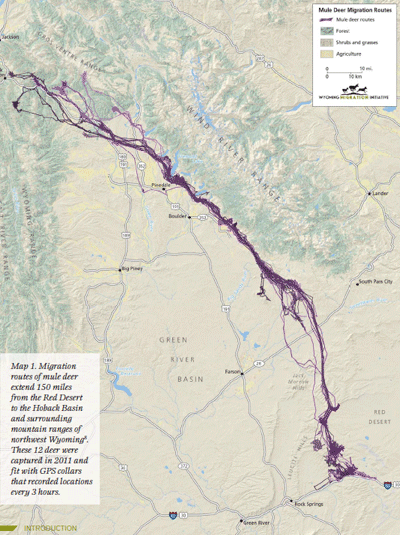
Western Wyoming supports some of the largest and most diverse ungulate populations in North America. The performance of these herds is largely dependent on their ability to seasonally migrate from low-elevation winter ranges to high-elevation summer ranges, where they gain fat needed to survive the long Wyoming winters. Recently, the longest mule deer migration ever recorded (and 2nd longest land migration in North America) was discovered where deer travel a one-way distance of 150 miles from the low-elevation winter ranges in the Red Desert to the high mountain slopes surrounding the Hoback Basin. The deer that complete this journey spend 4 months of each year migrating and encounter a variety of natural and anthropogenic obstacles, including sand dunes, lake and river crossings, multiple highways, and more than 100 fences.
Migrations like this are unique to Wyoming and are an important part of our cultural, hunting, and conservation heritage. However, given the increasing levels of energy development and recreation on public lands, sprawling housing development on private lands, and increasing traffic volumes on our roadways, the persistence of this migration route (and others) is uncertain. Additionally, the biological and political complexities involved with managing or conserving long-distance migrations outside of national parks is daunting. There is a pressing need to better connect the science of migration with conservation, education, and policy so that these management challenges can be met.
In an effort to better convey the science to migration stakeholders, the Wyoming Migration Initiative conducted a “migration assessment” of this newly discovered mule deer migration. The assessment identified specific locales of potential risks (e.g., fences, road crossings, bottlenecks, energy development) and considered the complex land-use patterns and associated policies through detailed mapping and analysis. By identifying potential risks to migrating deer, the assessment provides a roadmap for agencies, non-government organizations, landowners, industry, and other stakeholders to improve management and conservation efforts directed at the Red Desert to Hoback migration.
To complement our scientific assessment, we also built an outreach and educational program to generate interest and allow the broader public to learn about the migration. Specifically, we worked with National Geographic photographer Joe Riis to compile a traveling photo exhibit (12 photos and 2 maps) and short film that convey the story of this spectacular migration and the challenges mule deer must overcome to complete their 300-mile round-trip journey.
This project is led by Hall Sawyer, a research biologist at the Western Ecosystems Technology (WEST), Inc.
Report Downloads
Data Download
project funders
Project cooperators for the initial study include the Rock Springs Field Office of the Bureau of Land Management and Western Ecosystems Technology, Inc. We are grateful to the George B. Storer Foundation and the Knobloch Family Foundation, who funded our assessment of the Red Desert to Hoback migration and believed in our vision of a new way to connect migration science to on-the-ground management and conservation. We also had assistance from the Cornell Lab of Ornithology, the Wyoming Game and Fish Department, and the University of Wyoming’s Biodiversity Institute.
project timeline
This project originated from a BLM-funded study that Hall Sawyer conducted at his work with WEST Inc. The goal of this study was to document the baseline movement and distribution patterns of mule deer that winter in the Red Desert, near Interstate 80. In January 2011, 40 deer were equipped with GPS collars that collected locations every 3 hours for 2 years. The GPS collars were recovered in April 2013, revealing the 150-mile migration. The Wyoming Migration Initiative team then worked from April 2013 to April 2014 to complete the Red Desert to Hoback Migration Assessment. Joe Riis began work on the project in the fall of 2012, testing different camera equipment and scouting various areas. Most of Joe’s images and video were captured in the summer and fall of 2013. His photo exhibit and short-film were completed in April 2014. The photo exhibit traveled throughout the state in 2014 and 2015 as part of our outreach efforts to raise awareness of this and other ungulate migrations. Concurrently, the WMI team will provide technical assistance to agencies and other groups actively involved with the management and conservation of this migration. WMI researchers conducted a new capture of 20 Red Desert deer in March 2014 to enable long-term monitoring of this migration, with the aim of better understanding their migratory movements and their response to land-use changes and habitat enhancements.